I was so busy at my job from 7/1/17 to 6/1/18 that I never was able to take a vacation day. So I decided that after I left work on June first, I’d go to Alaska for a few months, then I’d take an extended backpacking trip in the High Sierras. I had the idea of hiking from Bridgeport to Lone Pine–surely a great trip—an I applied for a permit that would allow me to cross Donohue Pass, just south of Tuolumne Meadows, but I did not win a permit in the daily lottery on any of the 14 days I entered my name. So I decided to enter the mountains just south of that pass, from the June Lake area, but in the spring I was working hard all week and moving out of my apartment on weekends, so didn’t have time to plan the trip. What needs to be planned? The resupplying of food and a few other things like batteries. No big deal, I thought, I’ll pull it together once I arrive in the Owens Valley, on the east side of the Sierras. But after a couple days in the towns along Highway 395 I realized I had to shift to plan C. I couldn’t get a single horse or mule packer to take a supply of food into the mountains for me. Back-country lodges who offer resupply services to thru-hikers require that you mail them your provisions at least 3 weeks in advance.
Well, I’ve seen most of the country I was going to hike–been on most of the trails already. Plan C: go hike some sections of trail I’ve never seen.
My first hike began at South Lake, West of Bishop. The route would take me over Bishop pass (11,972’), down to LeConte Canyon, Northward, over Muir pass and into Evolution Valley, and then up the Piute Canyon heading Eastward and over Piute pass to North Lake. I would then try to hitchhike back to South Lake. It would be a 56 mile route if I didn’t deviate from the trail, but I wanted to explore the high lakes near Piute pass. So it would be 60 miles in 6 days. Just right.
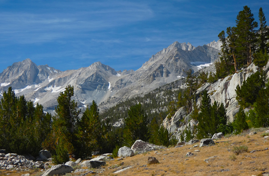
The first day retraced the route that I hiked in 2010 with Lauren and Dan–over the pass and into Dusy Basin. Dusy is such a beautiful setting—many small lakes at the feet of granite peaks—that on the last trip we laid over for a day and explored the basin and the high granite beyond it to the south without backpacks. This time I blew right through to the West end of the basin, trying to get some miles to allow me to be near Muir Pass the next day. Notable during the hike was the collection of about 15 deer carcasses in the talus just below the pass. I’m guessing they gathered on a cornice in winter and the cornice broke. They fell and the cornice toppled on them burying them in snow. After the hot summer all that was left was bones, some dried and hardened sinew being picked by ravens, and a little fur.
I found a good camp at the lowest lake of the basin as light rain began. A few aspirin helped me sleep with the elevation headache that I expect–a guy from sea level arrives to the Sierras and carries a pack over an 12,000’ pass.
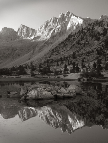
Dusy Basin
The morning light was good, and I got a few photos before I descended to LeConte. That descent was so beautiful (again) that it made me a little mountain drunk and I took a brief video of the experience:
And that was before descending into the grove of huge, ancient Junipers that made Lauren cry on the last trip. There trees are spectacular and have stood on these slopes for many centuries.
At the bottom of the canyon I hit the Pacific Crest Trail (also the John Muir Trail) and turned North instead of the South turn we made last time. Heading into new country, I hiked for a few hours among thick-trunked old growth pines with sheer granite walls overhead. Eventually the forest dwindled as I gained elevation and in the late afternoon I was hiking in a barren rock landscape towards Muir Pass (11,955’). There is a series of lakes on the approach to the pass, and they are surrounded with talus, so tent sights are few and far between. A hiker who was descending told me he saw a good camp on a hogsback between the trail and the stream about a half-mile ahead, and I was looking forward to dropping my pack. When I got there another hiker had taken the site. I pushed on to the next lake which was in a bowl of talus and had no place to camp. I dropped my pack and looked all over, finally finding a flat rock just big enough for my tent. It had a bunch of marmot shit on it, and a puddle of water from last night’s rain right in the middle of it, but it looked good to me.
In the morning I was over the pass within an hour of breaking camp. This pass features a stone hut with an igloo-like dome roof. It was built in 1930 for hikers to take refuge if needed.
Down I went, through Evolution Valley, where the granite is more broken and fractured than I had hoped. Funny how we respond to the aesthetic quality of unbroken granite; its resistance to erosion, its clean lines. I was reminded of the forward that Thomas Campbell wrote for Moved By A Mountain.
This basin has many features named by John Muir: lakes named for his daughters (how did he support them if he was out screwing around in the mountains all the time?) and peaks named for scientists with insights about evolution.
After about 11 or 12 miles, I wandered through the woods, way off the trail to the edge of Evolution Creek and made camp on a smooth granite bench beside a small waterfall.
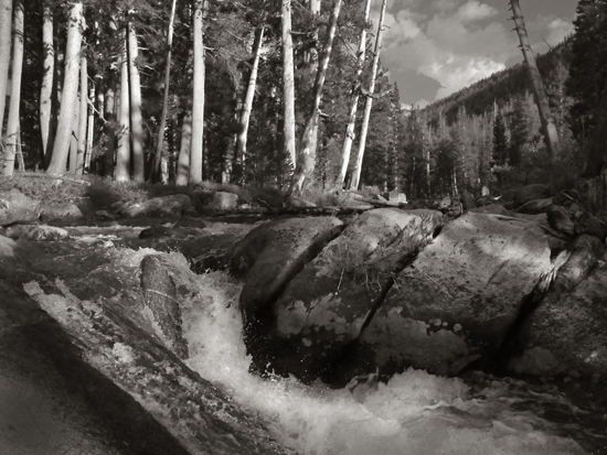
Evolution Creek
A big tree fell in the middle of the night.
In the morning it was onward to low elevation along the creek, only to turn up Piute Canyon and make for the high pass. I am always trying to travel light, and water is heavy, so if I think I can get water ahead, I will allow myself to run out of the life-giving liquid. Sometimes I make a mistake. The big side-valley on the north side of Piute Creek had been baked by the sun all summer and was bone dry. I was parched by the time I hit water about 4 miles into the ascent. I drank a liter and refilled for the rest of the day’s ascent. I positioned myself for the off-trail exploring the next day, and made camp by Piute Creek, well below tree line. Besides the beauty of being in old-growth forests of pines and aspens, and being able to get more oxygen from the air, there are two good things about the low country in the valleys between the high granite of these mountains. One is the ability to have a fire at night, the other is the ability to bathe in the streams (the water and air are a bit warmer, making it tolerable). This year all fires were prohibited, but I got clean two nights in a row.
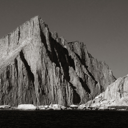
On day five I approached Piute Pass (11,9460’), but left the trail a half-mile before the pass to cross a tundra valley, and scramble up talus to the shore of Muriel Lake, and from there on up to Goethe Lakes, a pair of tarns sitting in a cirque with the same name. As the sun lowered, the views from the ridge above the lake were rewarding. The granite walls of Goethe Cirque were well-lit.
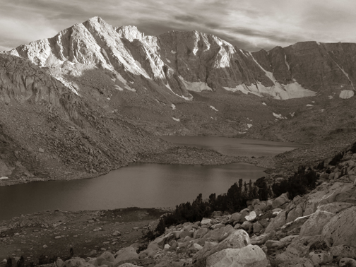
Goethe Cirque
And Mt. Humphreys, to the North, took on a glow:
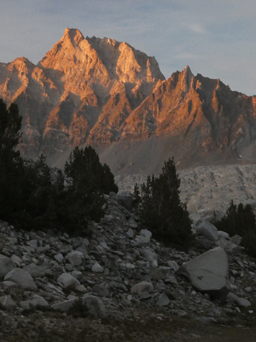
Mount Humphreys from camp in Goethe Cirque
My last day was an easy descent to Piute pass and on down to North Lake. I got lucky and was back at my van at the South Lake parking lot an hour after hitting the road, thanks to a pair of kind drivers.
After a few days of eating in Bishop, including the traditional steak at the bowling alley and a few fine ales at the new brewery, Mountain Rambler, I was ready for another hike.
from the Pine Creek trailhead
A bartender at the brewery became my friend, and he recommended the country above Pine Creek. It was a good idea. I had no set plan of travel. The idea was to ramble around the high granite and lakes in the area. I went up into the Granite Park area, but drifted off trail towards an inviting pass where I made camp at 11,800’ on the shore of the upper Royce Lake.
At this elevation the sky on a clear day is dark blue, and if I had better eyesight I could probably see stars.
Before my dinner of instant mashed potatoes and butter and jerky, I reconnoitered the next pass to the North and found it passable. So in the morning, after a night under the brilliant full moon, I traversed the talus and slid through the pass on a snowfield, and descended into the Granite Park, an impressive amphitheater. I was on a mission to cross two more passes that day, so I didn’t linger. I had lunch in the lee of a big boulder in Italy Pass, in the NW corner of the “park”, at about 12,000’. The wind was stiff and chilly, so I didn’t hang out long. Through the pass, I immediately traversed the talus bowl around Rubble Lake to walk through the pass to White Bear lake to the South, and then to the shores of Black Bear Lake, which is nestled up against the west side of the wall that forms the west side of Granite Park. Here was my camp, at 11,600’, and I had time to go explore the neighboring lakes, all with bear names. These are the Bear Lakes, at the Eastern foot of the majestic peak called Seven Gables.
Seven Gables from Black Bear Lake
There is a pass from Black Bear Lake into the Granite Park, and it looks like a cakewalk from the lake, but having been through the park the day before, I knew it was very steep on the other side, and I was working on deciding where to go in the fine morning. The other passes in the area all lead to valleys that drop below tree line, and I didn’t want to leave the high country, so I decided to negotiate that steep pass. I was on no mission this day, so it was a lazy morning, and only a one-hour ascent to the pass—easy, at times following deer prints in the scree which gave me confidence. If deer can do it, I can. Another lunch in a pass (cheese and jerky). I walked along the top of a tiny glacier (the remnants of a much bigger one on the map) hanging in the pass, trying to see what challenges were below, and I couldn’t see. It was that steep. But off to the North side I found a route through the steep talus and scree, and took it, slow and steady, for an hour until I was able to traverse out of what was a very wide couloir, and on to a ridge that led back into the “park.” I was crossing the bottom of the amphitheater when I turned around to see the granite spires beyond a nearby small waterfall, and was stunned. What a gorgeous place! Why go anywhere else? It was only noon, but I dropped my pack. This would be my camp. I wrapped my pack in my silver groundcloth and took off to see the rest of the amphitheater.
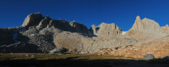
Camp (tent at right) in Granite Park
After all this time in the high country I had produced more hemoglobin to carry every bit of oxygen that I could grab out of the thin air, and with no pack I felt good scrambling around the big basin, but when I climbed the central knoll, I was still breathing hard—“Sucking the wind”, we used to say as oarsmen. I typically breathe like Darth Vader if I’m ascending a slope at over 12,000’.
The view from the knoll was impressive:
My camp was stunning, at the base of a granite outcropping, with a large tundra meadow carved by deep rivulets of pure water, home to young trout. Wandering about the meadow, I enjoyed the last sun of the day and got in bed once that heat source was gone and the temperature dropped. I was up at midnight though to enjoy the moonshine that lit the park well.
By morning the slow-moving sections of the rivulets were capped with ice, and the meadows were alive with flocks of pipits looking for breakfast.
After breakfast I was almost out of food, so I walked about 10 miles and descended about 3,500’ to the trailhead, with great pleasure. See video:
My lunch spot was a sweet crossing of Pine Creek that, lower down, tumbled off steep slopes of granite. I sold books in the trailhead parking lot, and took the money to Bishop to buy food and ale at Mountain Rambler.
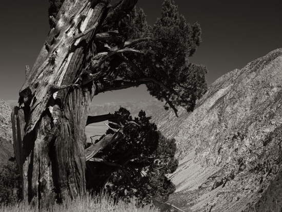
An ancient juniper overlooking the Owens Valley
I was running out of time before my school started in September, but had a few days to spare, so I decided to hike up to Mono Pass from the Mosquito Flats trailhead, which is way up a road from Tom’s Place. This was an easy hike up to Ruby Lake, where I dropped my pack, and then a steady climb to the pass (10,600’).
The ascent to Ruby Lake
In the pass there is a small lake that has good water. From there I ascended the ridge between the pass and the Fourth Recess. Years ago, on another backpacking trip with Dan and Lauren, we camped at the Fourth Recess and explored Pioneer basin. We entered the mountains from Lake Thomas Edison, about 15 miles to the west, down Mono Creek. It was interesting to look down on all that country, and so much of the country to the North to study the lay of the land. in the distance were the Minarets, which I wrote about in this blog just a couple years ago. See video:
back at the lake I had a little bivouac in some small firs on a granite ledge overlooking the glacial tarn, and watched trout breaking the surface for bugs at sunset. See video:
I would hike out the next day and make my way back to the Bay Area, making the traditional stop at the Iron Door Saloon, the oldest continually operating saloon in California, for their spicy “Rimfire Burger” and a local IPA.
The high granite is medicine for my soul that makes me feel more alive, fills me with appreciation for this planet, and appreciation for my strong body. The views are stunning, but when you’ve spent so much time up there that you no longer get stunned, its time to leave.

